
The Dirty Mayo (Full Cycle Edition)
- RideGravel.ca
- Oct 11, 2019
- 2 min read
Updated: Mar 22
Route Auteur: Grant Burke
Location: Mayo, Papineau Regional Municipality, Quebec
Estimated Gravel Time: 65%
Full Route Map:
Distance: 82.2km
Suggested Tire Width: 35mm or wider
Amenities: The village of Ripon, just short of the halfway point, has every amenity a rider could want including a couple of grocery stores and dépanneurs, and restaurants.
Parking: Anyone participating in Full Cycle’s Shield and Valley Gravel Series are advised to park at the St. Malachy Catholic Church. Otherwise, parking is available at the corner of Route 315 and Chemin Mcalendin
Route Description:
Located in the southern foothills of the Laurentians, Mayo was originally settled by Irish immigrants in the early 1800s, and was named after the rolling hills of County Mayo, back in the old country. In other words, be sure to pack your climbing legs for this one!

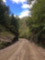
Starting from the corner of Route 315 and Chemin Mcalendin in the village of Mayo, ride counterclockwise via Chemin Roy as the route immediately transition from pavement to gravel. Just over a kilometer later, turn left onto Chemin Burke where riders will be treated to an extended stretch of tree-lined gravel, which eventually shifts to exposed farm land before turning right onto Montée Dambremont.

Eventually, the route turns left onto Montée Binette and Montée Varin, two wonderfully twisty gravel sections – and where the climbing begins in earnest. This is followed by a left as the route briefly follows Route 317 (while traffic can move fast here, there is a wide paved shoulder), before the route turns right and back onto gravel via Montée du Gore.
The route eventually re-joins Route 317 and for the next 18km or so travels along several stretches of pavement including Montée Guindon, and Chemin de St. André, before entering the village of Ripon. Be sure to ride single file on this section, as there is no paved shoulders and traffic along Route 317 can travel at a high rate of speed.
The village of Ripon, little less than halfway along the route, is a convenient stop for hunters headed north and as such includes all the amenities a cyclist could want, including several restaurants, chips stands, grocery stores and dépanneurs. Exiting the village, the route heads west along Chemin de la Montagne before turning left onto Chemin de la Montagne Noire, leaving the pavement behind and beginning the loop’s most difficult climb, quickly followed by a sphincter-clenching descent down the other side of Black Mountain.
The road then continues for several kilometers of gravel bliss before returning to pavement for a short stretch, followed by a right onto Chemin Smallian as riders continue on gravel via Chemin Miller and Chemin de la Riviere Blanche. Eventually, the route rejoins Route 315 and heading south all the way back to Mayo.
